 For the past few years, the college-level course on African-American History at the School for the Creative and Performing Arts has been dedicating time to research for WHHS. This year, the class worked on the 1900 census, Enumeration District 15. The previous class had completed Enumeration District 14. Together, these districts comprise the heart of Walnut Hills’ Black neighborhood — from Churchill south to Yale, and from Gilbert east to Ashland. We have learned much from this work and are so grateful to Brynn Thomas and her students for their careful transcription of the census pages!
On this page, you’ll find links to some of the analysis we have completed on the 1900 census: maps, links to the database itself, statistical analyses, and other research. We intend to continue working with this data, adding to it and expanding our understanding of Walnut Hills at the turn of the 20th century using more census information.
Sources: Where to find the census pages and how to interpret them
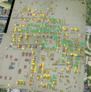
Maps: The neighborhood in 1900
Analysis: Literacy, home ownership, occupations (coming soon!)